RELAX OVERNIGHT TRIPS
As a tourist visiting Hong Kong, the average layover time is less than a week. Spending a couple of days outdoors is certainly a great choice to see the countryside of Hong Kong, while you won’t miss anything in the city. You may want to maximize the outdoor culinary experience during the overnight camp or dig a little deeper into what the countryside can offer.
Overnight camping doesn’t have to carry a heavy bulky bag and walking long distances. If you prefer resting next to a campfire sipping your favorite wine, or enjoy the sea breeze over a hammock reading your never-finish book. I got you covered.
Route Suggestion (1) – Winter Campfire
Recommended Activities: Short Hike, Campfire Cooking,
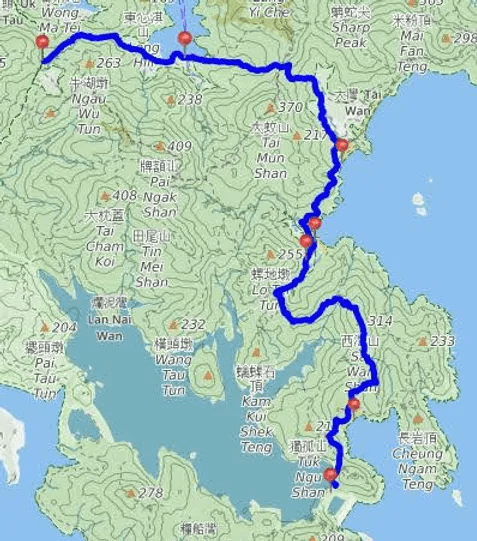
Countryside Map Index: Lantau Island & Neighbouring Islands
Trails: Lantau Trail Section 12
Start Point: Pui O Bus Stop
Finish Point: Mui Wo Ferry Pier
Campsites: Pak Fu Tin Campsites
Water Sources: Tap water from the toilet next to start point and stream next to the campsite
Possible Resupply Point: Village Store (HE 074 621) for drink mostly
Trip Distance: 8.5 km / 5 miles
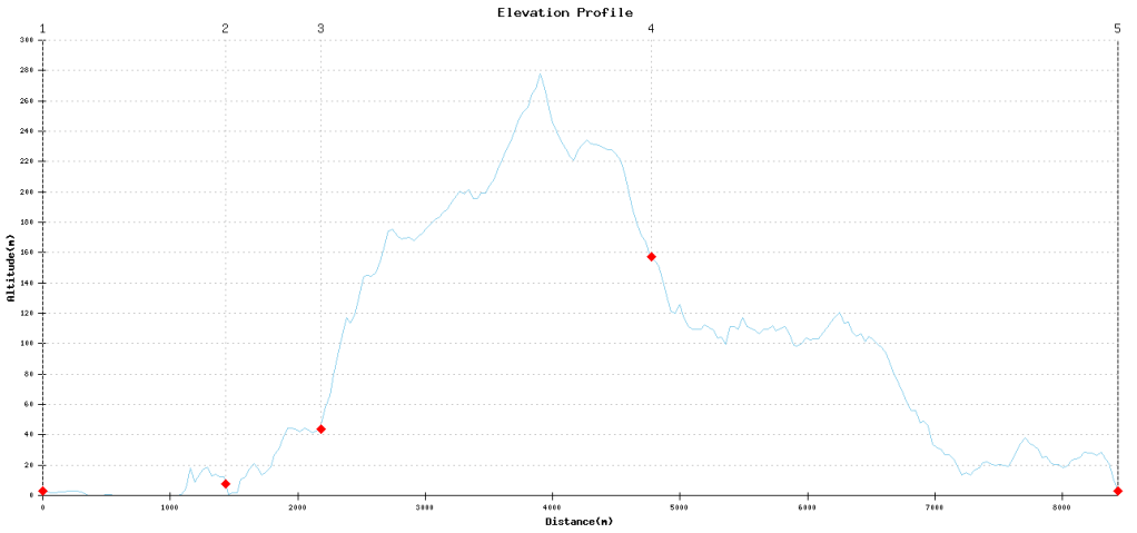
Elevation Profile:
Waypoints:
Point 1 – Start Point: Pui O Bus Stop (HE 068 628)
Point 2 – Village Store (HE 074 621)
Point 3 – Additional Trail Option (HE 079 623) to Chi Ma Wan Country Trail (18.5 km / 11.5 miles)
Point 4 – Pak Fu Tin Campsites (HE 086 638)
Point 5 – Finish Point: Mui Wo Ferry Pier (JK 910 650)
Route Map
Route Suggestion (2) – Sea Sun Sand
Recommended Activities: Sun, Sand, Sea
Countryside Map Index: Sai Kung & Clear Water Bay
Trails: Maclehose Trail Section 2
Start Point: Pak Tam Au
Finish Point: High Island East Dam Pavilion
Campsites: Long Ke Wan Campsite, Sai Wan Campsite, Ham Tin Wan Campsite
Water Sources: Tap Water from the toilet at Pak Tam Au, Chek Keng and High Island East Dam Pavilion
Possible Resupply Point: Vending Machine at the start point, Village Cafe near Ham Tin Wan Campsite and Sai Wan Campsite
Trip Distance: 15 km / 9 miles
Elevation Profile:
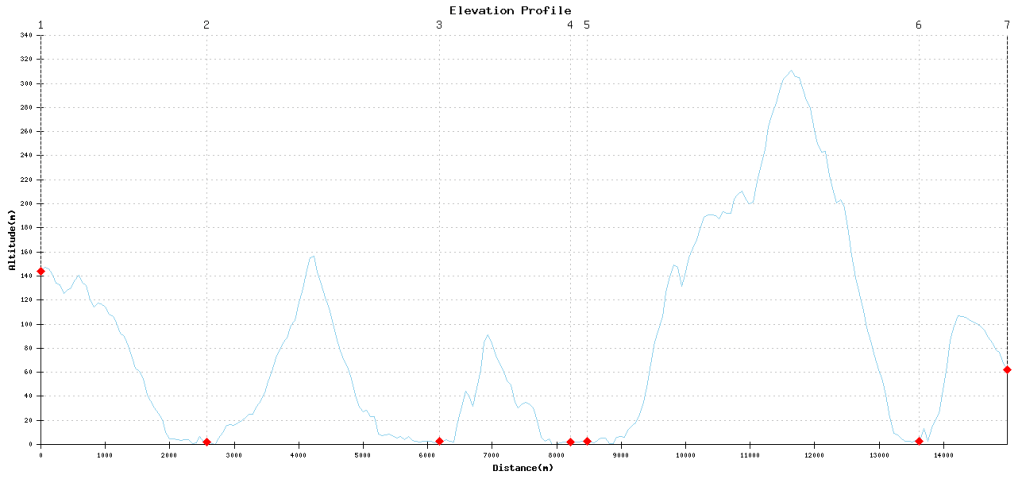
Waypoints:
Point 1 – Pak Tam Au (KK 254 819)
Point 2 – Chek Keng Public Toilet (KK 275 819)
Point 3 – Ham Tin Wan Campsite (KK 297 805)
Point 4 – Sai Wan Campsite (KK 293 795)
Point 5 – Village Cafe near Sai Wan Campsite (KK 293 795)
Point 6 – Long Ke Wan Campsite (KK 296 766)
Point 7 – High Island East Dam Pavilion (KK 295 755)
Route Map